By VERNON ROBISON
Moapa Valley Progress
The Clark County Board of Commissioners approved a resolution on Tuesday that called on Nevada Congressional delegates to introduce a new broad-sweeping public lands bill for southern Nevada.
The suggested measure would open more than 44,000 acres of public lands for new development south of Las Vegas between Sloan and Jean east of Interstate 15.
It would also set aside more than 300,000 acres of new conservation land throughout the county.
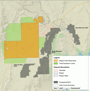
The resolution aimed more than half of the proposed conservation lands, about 56,000 acres, at the outlying areas of northeastern Clark County. Most of that land is immediately surrounding the Moapa Valley communities.
Nearly 10,000 acres, being referred to in the resolution as the Mesa Milkvetch Area of Critical Environmental Concern (ACEC), is located directly adjacent to the communities of Logandale and Overton in what was previously marked as BLM disposal land on the neighboring east bench of the valley. The draft maps accompanying the resolution show no buffer between the proposed ACEC and privately held parcels along the east edge of the lower Moapa Valley communities.
In addition, more than 37,000 acres is proposed as a new Muddy Mountains ACEC, located in the range immediately west of the Logandale Trails area.
A roughly 9,000 acre California Wash ACEC would also be designated in the open desert area just south of the Paiute Travel Plaza.
After a motion to approve the resolution was made by Commissioner Marilyn Kirkpatrick, the measure was approved with a 6-0 vote of the Commission.
The vote followed nearly two hours of public comment, most of which was opposed to the measure. A large contingent of off-road enthusiasts expressed outrage at the prospect of losing what they said was the last remaining tract of recreation land still open for organized OHV use and off-road racing events.
During Board discussion, Kirkpatrick talked about her close involvement in drafting the resolution which began nearly a year ago. She said that she had worked carefully with Clark County Department of Air Quality and Environmental Management Director Marci Henson and other county staff in the process, and credited the staff for their diligent efforts in coming up with what she felt was a balanced approach.
Kirkpatrick also said that she had met with various groups, spoken to community leaders and even had travelled to Washington DC for meeting with Nevada Congressional delegates on the subject.
In particular, Kirkpatrick emphasized that she had worked with stakeholders in the northeast Clark County communities and had made every effort to include those rural community interests in the resolution.
“We sat with all of the different agencies and groups out there whether it was Overton Power or Moapa Valley Water District (MVWD); and of course the Moapa Band of Paiutes; to have these different discussions and include them,” Kirkpatrick said.
In addition to the tribal land annexation, the MVWD is specifically mentioned in the resolution. It proposes that lands be conveyed to the MVWD for critical water infrastructure projects. This would alleviate the costly process of obtaining and maintaining permits on the district’s infrastructure.
Kirkpatrick also explained that the resolution would take BLM land; currently under lease for public school, recreation and infrastructure purposes; and convey it to county or municipal ownership. The BLM currently owns lands upon which many county parks, schools and other facilities are built, she explained. That brings another layer of permitting requirements to any uses of those facilities, she said.
As an example, Kirkpatrick cited the mud bog race that once took place in the parking lot area east of the Logandale Ballfield complex. The race had to be cancelled and held in another community because of the added red tape involved with getting BLM approval.
Kirkpatrick also touted that she had worked to keep BLM disposal lands marked for future development in place for the Moapa Valley communities. According to the resolution, a total of 32,487 acres of BLM disposal lands were retained in the greater Moapa/Glendale/Moapa Valley area. That was down from 41,626 acres in the previous BLM designations.
But Kirkpatrick emphasized that much more of those lands had been in danger of being taken off of the disposal list by the BLM in their recently proposed Resource Management Plan documents.
“I said adamantly that I have to have disposal land available in the Moapa area,” Kirkpatrick said. “That’s because (those communities) don’t have much of a tax base up there and they have to have somewhere kept open for them to grow.”
But one public commenter with local ties said that a shift in the disposal lands available to the lower valley communities of Logandale and Overton is problematic. Regional real estate developer Tony Ricco, formerly of Logandale, pointed out that the resolution proposes to establish the Mesa Milkvetch ACEC in the vast east bench area that is currently established as disposal land. In its place, the plan would establish a much smaller area of disposal land to the north of Logandale.
Ricco insisted that the east bench lands should be kept as disposal land while the northern areas would be better suited for conservation lands.
“If you really have a conservation goal, switch that conservation element to the northern end of the valley to include the (abandoned) Royal Cement plant which is an EPA superfund site; and the areas that have over 15 percent grade which will never go into private hands anyway,” Ricco said.
Ricco pointed out that the Moapa Valley is one of the only communities in southern Nevada that has ample water resources and wastewater treatment capacity for development. “We need to have more developable private lands in outlying areas where we have that capacity,” Ricco said.
Ricco also raised concerns about the lack of detail in the maps being presented as part of the resolution package. “In all of these designations, there is just a mark on the map,” Ricco said. “There is no text specifying township, range and section. I don’t even know where a lot of these properties are because there is no text.”
County Commissioner Jim Gibson followed this comment up by asking staff to clarify why there were not specific text for the maps.
“We are very early stage in the process,” said Henson. “We are just identifying general areas for future designation to submit to the Congressional delegation as a starting point. Within a certain timeframe, the Department of Interior would be required to prepare legal description of these areas.”
Much of the public comment also expressed frustration at the short, two week timeframe for public involvement. Many complained there had simply not been enough opportunity for public input in the process.
Henson admitted that the county was under a tight time constraint to act on the matter. But this limitation was not entirely the county’s doing, she said.
“A couple of months ago, we were notifed that local BLM had been given a directive by Deparment of Interior officials that they had to be done with the Resource Management Plan (RMP) within a year,” Henson said. “That was completely unanticipated.”
The RMP, which has not been updated since 1998, is a sort of blueprint guiding the land-use decisions for 3.1 million acres of federal land in Clark and Nye counties.
Henson said that it was important that the county act immediately to start the legislative process on a lands bill so that it would be in the pipeline while the truncated RMP process is ongoing.
“If we don’t move forward with this in a timely manner; and by that I mean today; then local BLM operatives will create alternatives for the RMP and complete their assignments within the year,” Henson said. “That means that the RMP will make land use allocations that may or may not comport with decisions we have made as a county. Those changes will be irreversible.”