


By VERNON ROBISON
The Progress
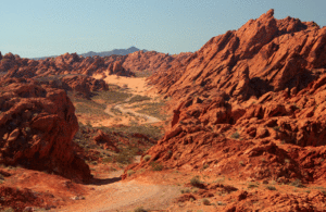
The Bureau of Land Management (BLM) is seeking public input on the very beginnings of a planning process for the Logandale Trails Area, one of the few public land areas in southern Nevada still open to motorized vehicle recreation.
The BLM is in the middle of a 45-day public scoping period which began on October 22. Public comments in this phase of the project will be accepted through December 6.
A virtual scoping meeting was held Wednesday night, Nov. 17 by the BLM on an online platform. In the meeting, BLM representatives presented information about the project and allowed for questions and comments to be made by the public.
According to the presented materials, the project consists of an amendment to the BLM Resource Management Plan (RMP). This amendment would change the designation of the 15,000 acre Logandale Trails area from an Extensive Recreation Area, which is managed for unstructured and dispersed recreation, to a Special Recreation Management Area, which manages the land with recreation as its primary focus.
“An increase in local population and recreation-based activities has amplified the need for improved recreation management at Logandale Trails in order to improve recreation management,” said BLM Project Lead Kenny Kendrick at the meeting. “This plan will serve as a guiding document for managing recreation use in the area.”
Kendrick listed various recreational uses including off-highway vehicle use, camping, hiking, target shooting and special events. “The goal is to provide the BLM with site specific goals and strategies for managing the area to achieve desired recreation outcomes while avoiding conflicts between recreation with other uses,” Kendrick told attendees.
Kendrick said that the RMP amendment would also involve the development of a Recreation Area Management Plan and a detailed Travel Management Plan.
The Travel Management Plan would involve creating a full inventory of all routes, trails and roads through the area. It would then do a full analysis of the roads to determine any management action, Kendrick said.
BLM staff had created an interactive map of all known trails in the system. This map is available for public review at https://www.virtualpublicmeeting.com/Logandale-trails-ea.
At the meeting, the public was encouraged to submit GPS tracks or other mapping files to show trails or roads that may not be included in the current map.
“We are gathering all information during this period; and developing new routes and trails is a possibility,” said Kendrick. “So if you guys know of any new routes or trails that are not on the inventory, we would like you to submit those routes so they can be processed.”
When asked whether there were any plans to close any current roads, Kendrick responded, “At this time, there is no proposal to close down any motorized public access.”
But later in the meeting, Kendrick allowed for the possibility that certain roads might be limited in the process based on a full analysis of the complete inventory of routes.
“Once we get that complete inventory of all the routes out there, each route will be analyzed and some of the routes, it is possible may make it on or some may not depending on the circumstance,” Kendrick said. “Like some routes that might lead to certain sensitive sites, those are possibilities where a route might make it on and another one may not.”
Vegas Valley 4-wheeler organization president Kevin Bailey asked what the plan would be for the many rock-crawling trails in the area and whether any of these would be considered in the trails plan.
“We realize that there are a lot of rock crawling opportunities out there and we are analyzing that at this time,” Kendrick said. “There has been no decisions made at this time if an area is going to be closed or not.”
Kendrick added that comments should be submitted by members of the public showing all areas being used for rock crawling. “If there are any routes that you have GPS tracks for, or KML files or shape files; things like that; you can send them to BLM and they will be included in the analysis to consider,” Kendrick said.
Several questions from the public asked for specifics about the alternatives that the BLM was proposing for the project. But BLM staff members insisted that the project is in its initial stages and no changes are being proposed yet. “We haven’t made any decisions at this point,” Kendrick said. “We are still in the process of gathering information from the public and other interested parties.”
In a public comment, Logandale resident Marcus Jensen expressed concern about the problem of designated routes from Logandale Trails leading to privately-owned property. Jensen said that he encouraged the BLM to permit the use of all existing trails as much as possible.
“However, any road or trail that leads to private lands or to restricted areas should be fenced or flagged or have signs posted in some manner to discourage trespass,” Jensen said.
Jensen suggested that where trespass occurs, BLM should accept enforcement and prosecutorial responsibilities.
Overton resident Garen Fullmer asked whether any plans were being made to assign a dedicated law enforcement BLM ranger to the area.
“At this point, we don’t have plans for that,” Kendrick said. “Certainly that would be some input that we would look for from the public during the scoping process and we would appreciate any thoughts on that.”
In a comment, Overton resident Lori Houston stated the concern that not enough engagement from the Moapa Valley community had been sought by the BLM in this process.
She pointed out that this first meeting held on the topic was already nearly a month into the 45 day process.
“It is not enough time,” she said. “And tell me if I am wrong, but I didn’t see one local person or entity or group in that list of planning partners on this project. I think that needs to be rectified. This could have a major economic impact to our community and it just doesn’t feel like we have had a lot of local input.”
The public scoping period is open through Dec. 6. Comments may be made via email at BLM-NV_LVFO_Logandale_RAMP@blm.gov, by telephone at 702-515-5073 or by U.S. Mail at BLM-Las Vegas Field Office; ATTN: Kenny Kendrick; 4701 N. Torrey Pines Drive; Las Vegas, NV 89130.
For more information and updates about the process, visit https://www.virtualpublicmeeting.com/logandale-trails-ea.


1 thought on “BLM Comment Period Open On Logandale Trails Plans”
Excellent point made at the end of the article. A local resident or two must be on the planning committee. This is a seriously impactful long term plan which will carry the local community into the future use of Logandale trails. The trails are used by visitors from NV and all other bordering states.