


By VERNON ROBISON
Moapa Valley Progress
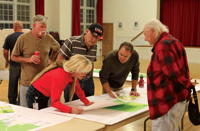
A handful of Moapa Valley residents attended a series of two meeting last week to give input on a process that can shape the future of the community. The meetings were just the beginning of Clark County’s Land Use Plan update for the northeast rural communities.
The first meeting, held on Tuesday, Nov. 7 in the Old Logandale School, dealt with planning documents for Logandale including lower valley parcels north of the Lou Jean alignment. The second meeting, held the following evening in the Overton Community Center, was focused only on Overton including parcels south of the same boundary.
Large maps were laid out on tables showing each parcel clearly. Residents could review the maps, see the current land use category assigned and make suggestions on preferred changes to the final Land Use Plan update. Attendees were even given colored markers and encouraged to mark the maps with their proposed changes.
The Land Use Plan is the document that guides all development and zoning decisions in the area. It is updated by the county every five years.
In the Plan, every parcel in the community is assigned a land use category. These categories give a general determination of where different uses are appropriate in a community. Certain areas might be set aside for agricultural land, industrial uses, commercial development, residential projects and more.
Each of the categories have a range of densities or intensities of use. For example, a Residential Rural category is designated for having no more than one dwelling on two acres. Other residential categories frequently found in Moapa Valley include Residential Agricultural (1 unit per acre), Rural Neighborhood (up to 2 units per acre) and Residential Low (3.5 units per acre). In Overton and Logandale, there are even parcels with land use planning densities of 8-12 units per acre.
In the weeks leading up to these first public meetings, staffers from the office of County Commissioner Marilyn Kirkpatrick worked hard to let people know the importance of the process. Kirkpatrick’s community liason Janice Ridondo said that the Commissioner’s office receives phone calls regularly from local residents who complain about some detail in land use planning that they don’t like; or something that, they feel, doesn’t make sense. She emphasized that this process is the time to bring all of those issues forward.
“Now is the time to try to address those things,” Ridondo said. “This is the chance to make changes. We want to hear from everyone who has a problem or a viewpoint on something. But folks need to understand that when this process is done, you don’t get to call and complain if you haven’t been part of it.”
Despite this message, turnout at the meetings was sparse.
The Logandale meeting on Tuesday night had the larger turnout with around two dozen people in attendance.
Much of the discussion in Logandale surrounded a block of land on the eastern edge of Logandale. Earlier this year, a developer had proposed a residential project on 23 acres just south of Gubler Ave and east of Whitmore Street. The parcel is currently zoned at 2 units per acre but has a Land Use designation allowing for up to 3½ units per acre. The developer had asked for a conforming zone change to allow the project to be built at the higher density.
Neighbors had verbally opposed the change, saying it didn’t match the density in the surrounding area. Hearing this opposition, the developer had pulled his request. He said that he would rework the plan with the wishes of the community in mind, and resubmit it at a later time. No new plans have yet been submitted.
A few of the same neighbors who had opposed the original proposal attended on Tuesday’s meeting. They discussed strategies on containing growth in that area and keeping the density in the neighborhood low. They also made specific suggestions on where higher density projects might be located in the community. All of these suggestions, though, were far removed from their own neighborhood.
This group also talked about the vast tract of BLM land, adjoining their neighborhood to the east, which has long been marked for disposal to private ownership. The neighbors wanted to consider ways that they might lock in a low density designation on those lands, if ever they were released for development in the future.
Attendance at the Overton meeting was even more sparse with about 8 people cycling through during the three hour time block.
Most of the discussion during that meeting was on small ‘clean-up’ items that needed to be addressed on individual parcels in order for landowners to move forward with their plans.
Ridondo was pleased with the community discussion that took place in the meetings. She was, nevertheless, somewhat disappointed that more of the community did not engage.
“I guess that I am going to have to go out and knock on people’s doors to get their feedback,” she said with a smile.
This is not the last chance for the public to weigh in on this process, though. Rather it is only the beginning. County staff is expected to hold more formal public hearings in the community during the first quarter of 2018. The plan will then be brought to the town advisory boards for their review and approval. At some point during the second quarter of the year, the final draft of the plan will be presented before the County Planning Commission for approval. Then, in a final vote, it will be approved by the Board of County Commissioners.
Keep your eyes on the PROGRESS for more details on the process.


1 thought on “Meetings Held To Start The County Land Use Plan Process”
It would be nice if the land use would require detention basins and ways to stop the flooding in this beautiful place. The people here are Superb, compared with the rest of Clark County!!!